Interactive Heat Risk Map for the Continental U.S. ** Highly Recommended **
National Weather Service
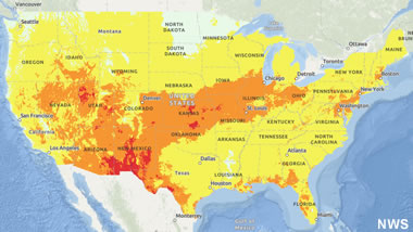
If you live in the continental United States, this interactive map is a great tool to help you prepare for the hot summer days ahead. Temperature is only one risk factor, and this map combines multiple metrics to determine the color-coded heat risk levels.
National Weather Service
If you live in the continental United States, this interactive map is a great tool to help you prepare for the hot summer days ahead. Temperature is only one risk factor, and this map combines multiple metrics to determine the color-coded heat risk levels.
8 Mistakes to Avoid if You're Going Out in the Heat
NPR
Don't underestimate the dangers of excessive heat. Over 2,300 heat-related deaths occurred in the U.S. last year, and this summer is predicted to be even hotter. Prepare yourself for sweltering temperatures with these smart tips from NPR.
NPR
Don't underestimate the dangers of excessive heat. Over 2,300 heat-related deaths occurred in the U.S. last year, and this summer is predicted to be even hotter. Prepare yourself for sweltering temperatures with these smart tips from NPR.
The Marcellus Continues as the Top-Producing Rock Unit for Natural Gas
Energy Information Administration

Graph by the Energy Information Administration using data from Enverus.
Energy Information Administration
Graph by the Energy Information Administration using data from Enverus.
United Kingdom Energy Report
Energy Information Administration

Statistics are now available for 2022 from the Energy Information Administration.
Energy Information Administration
Statistics are now available for 2022 from the Energy Information Administration.
USGS Estimates Conventional Oil and Gas Resources of the Northern Chukchi Basin
USGS

From the article: Using a geology-based assessment methodology, the U.S. Geological Survey estimated mean volumes of 1.8 billion barrels of oil and 119.9 trillion cubic feet of gas technically recoverable from undiscovered, conventional accumulations in Cretaceous and Cenozoic strata of the North Chukchi Basin.
USGS
From the article: Using a geology-based assessment methodology, the U.S. Geological Survey estimated mean volumes of 1.8 billion barrels of oil and 119.9 trillion cubic feet of gas technically recoverable from undiscovered, conventional accumulations in Cretaceous and Cenozoic strata of the North Chukchi Basin.
Earth's Magnetic Field Nearly Collapsed 600 Million Years Ago. Then, Complex Life Evolved
Smithsonian
From the article: A new study suggests more solar radiation reached Earth while the magnetic field weakened, leading to a rise in oxygen that drove an explosion of multicellular organisms during the Ediacaran Period.
Smithsonian
From the article: A new study suggests more solar radiation reached Earth while the magnetic field weakened, leading to a rise in oxygen that drove an explosion of multicellular organisms during the Ediacaran Period.
Some Midwest Towns Left Wondering: So Where Are All Those Cicadas?
WGLT
For months, people living in the midwestern United States have been anticipating the double emergence of two broods of periodic cicadas. But some residents of McLean County, Illinois have been puzzled by the noticable abscence of cicadas in their area. Why were some towns overrun by the insects, but not others?
Using Royalties from an Alaskan Oil Resource to Pay Down National Debt?
CNN
Shark Tank's Kevin O'Leary proposes using royalties from petroleum produced within the Arctic National Wildlife Refuge to pay down the national debt.
CNN
Shark Tank's Kevin O'Leary proposes using royalties from petroleum produced within the Arctic National Wildlife Refuge to pay down the national debt.
Coastal Plain of the Arctic National Wildlife Refuge
Bureau of Land Management

The 1,563,500-acre ANWR oil and gas program area referred to as the "Coastal Plain" is located along the coast of the approximately 19.3 million-acre Arctic National Wildlife Refuge (ANWR) on Alaska's North Slope. It is in the northwestern portion of the refuge immediately adjacent to the Beaufort Sea (Arctic Ocean) located to the north.
Bureau of Land Management
The 1,563,500-acre ANWR oil and gas program area referred to as the "Coastal Plain" is located along the coast of the approximately 19.3 million-acre Arctic National Wildlife Refuge (ANWR) on Alaska's North Slope. It is in the northwestern portion of the refuge immediately adjacent to the Beaufort Sea (Arctic Ocean) located to the north.
Oil and Natural Gas Resources of the Arctic
Geology.com
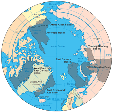
The United States Geological Survey estimates that over 87% of the Arctic's oil and natural gas resource (about 360 billion barrels oil equivalent) is located in seven Arctic basin provinces: Amerasian Basin, Arctic Alaska Basin, East Barents Basin, East Greenland Rift Basin, West Greenland-East Canada Basin, West Siberian Basin, and the Yenisey-Khatanga Basin.
Geology.com
The United States Geological Survey estimates that over 87% of the Arctic's oil and natural gas resource (about 360 billion barrels oil equivalent) is located in seven Arctic basin provinces: Amerasian Basin, Arctic Alaska Basin, East Barents Basin, East Greenland Rift Basin, West Greenland-East Canada Basin, West Siberian Basin, and the Yenisey-Khatanga Basin.
Landslide Closes Teton Pass Highway in Wyoming
WyoFile

Drone photo of the slide by the Wyoming Highway Patrol.
WyoFile
Drone photo of the slide by the Wyoming Highway Patrol.
New: Online Eruption Map by the Hawaiian Volcano Observatory
USGS

View of the island of Hawaii showing inactive eruption locations. You can zoom in a lot closer than this.
USGS
View of the island of Hawaii showing inactive eruption locations. You can zoom in a lot closer than this.
The 2,000-Year-Old Rock Art Along the Orinoco River
Smithsonian
Researchers believe that the giant snake-like petroglyphs may have served as prehistoric "road signs" to mark locations along the river.
Smithsonian
Researchers believe that the giant snake-like petroglyphs may have served as prehistoric "road signs" to mark locations along the river.
Types of Rock Art: Petroglyphs and Pictographs
Geology.com
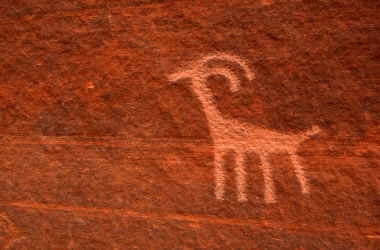
A petroglyph is an image that is carved into a rock. This "carving" can produce a visible indentation in the rock, or it can simply be the scratching away of a weathered surface to reveal unweathered material of a different color below. Image copyright iStockphoto / amygdala_imagery.
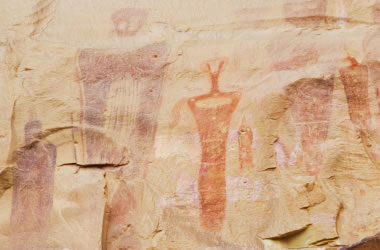
A pictograph is a drawing or painting that is created on a rock. It is not "carved" into the rock. Image copyright iStockphoto / Andrea Gingerich.
Geology.com
A petroglyph is an image that is carved into a rock. This "carving" can produce a visible indentation in the rock, or it can simply be the scratching away of a weathered surface to reveal unweathered material of a different color below. Image copyright iStockphoto / amygdala_imagery.
A pictograph is a drawing or painting that is created on a rock. It is not "carved" into the rock. Image copyright iStockphoto / Andrea Gingerich.
Kids Discover Tyrannosaurus Rex Fossil in North Dakota
Smithsonian
Three boys discovered the bones of a juvenile T. Rex while hunting for fossils in the Badlands of North Dakota. Fossils of young dinosaurs are very rare, so this specimen was a fantastic find.
Smithsonian
Three boys discovered the bones of a juvenile T. Rex while hunting for fossils in the Badlands of North Dakota. Fossils of young dinosaurs are very rare, so this specimen was a fantastic find.
Interactive Map: Sea Surface Temperature
NASA Earth Observatory

Sea surface temperature influences climate and weather in a number of ways, such as rainfall patterns and the development of tropical storms. NASA's interactive map allows you to see how the surface temperature has fluctuated from month to month since 2002. There are also other interactive world maps to compare and contrast, including land surface temperature, total rainfall, vegetation, fire, and others. The maps are based on observations by the MODIS sensors on NASA's Terra and Aqua satellites.
NASA Earth Observatory
Sea surface temperature influences climate and weather in a number of ways, such as rainfall patterns and the development of tropical storms. NASA's interactive map allows you to see how the surface temperature has fluctuated from month to month since 2002. There are also other interactive world maps to compare and contrast, including land surface temperature, total rainfall, vegetation, fire, and others. The maps are based on observations by the MODIS sensors on NASA's Terra and Aqua satellites.
Rare Blue-Eyed Cicada Found in Illinois
Field Museum
Four-year-old Jack Bailey has been enjoying collecting cicadas in his yard. His sister noticed that one of the insects had blue eyes, and it was later donated to the Field Museum in Chicago, Illinois.
Field Museum
Four-year-old Jack Bailey has been enjoying collecting cicadas in his yard. His sister noticed that one of the insects had blue eyes, and it was later donated to the Field Museum in Chicago, Illinois.
A Geological Wonderland in Alaska
NASA Earth Observatory

Adam's Inlet, located within Glacier Bay National Park, Alaska, has many interesting geological features. The area was covered by thick glacial ice just 130 years ago. Today, we see a landscape with braided rivers, alluvial fans, landslide debris, and turquoise-colored water from sediment plumes. Image by Wanmei Liang, using Landsat data from the U.S. Geological Survey.
NASA Earth Observatory
Adam's Inlet, located within Glacier Bay National Park, Alaska, has many interesting geological features. The area was covered by thick glacial ice just 130 years ago. Today, we see a landscape with braided rivers, alluvial fans, landslide debris, and turquoise-colored water from sediment plumes. Image by Wanmei Liang, using Landsat data from the U.S. Geological Survey.
Recent Lava Flows Suggest 'Ongoing' Volcanic Eruptions on Venus
Smithsonian
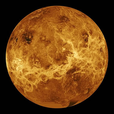
Shown above: A simulated color image of the surface of Venus created by NASA using radar topography data acquired by the Magellan spacecraft.
Smithsonian
Shown above: A simulated color image of the surface of Venus created by NASA using radar topography data acquired by the Magellan spacecraft.
Mapping the Volcanic Landscape of Venus
Geology.com
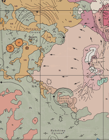
Geologic Map of Venus: USGS has produced detailed geologic maps for many areas of Venus. These maps have descriptions and correlation charts for the mapped units. They also include symbols for faults, lineaments, domes, craters, lava flow directions, ridges, grabens and many other features. These can be paired with NASA radar images to learn about volcanoes and other surface features of Venus.
Geology.com
Geologic Map of Venus: USGS has produced detailed geologic maps for many areas of Venus. These maps have descriptions and correlation charts for the mapped units. They also include symbols for faults, lineaments, domes, craters, lava flow directions, ridges, grabens and many other features. These can be paired with NASA radar images to learn about volcanoes and other surface features of Venus.
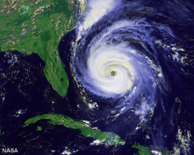
NOAA Predicts Above-Normal 2024 Atlantic Hurricane Season
National Oceanic and Atmospheric Administration

From the article: "La Nina and warmer-than-average ocean temperatures are major drivers of tropical activity." The satellite image above shows Hurricanes Idalia and Franklin on August 29, 2023. Image captured by NOAA's GOES-16 satellite.
National Oceanic and Atmospheric Administration
From the article: "La Nina and warmer-than-average ocean temperatures are major drivers of tropical activity." The satellite image above shows Hurricanes Idalia and Franklin on August 29, 2023. Image captured by NOAA's GOES-16 satellite.
How Are Hurricanes Named?
Geology.com
Hurricane Fran: Satellite image of a hurricane named "Fran." Hurricane Fran was a large, powerful, destructive hurricane that made landfall near Cape Fear, North Carolina on September 5, 1996. Fran was the sixth named storm of the 1996 hurricane season because "F" is the sixth letter in the alphabet. It was so destructive that the name "Fran" was retired from use. Satellite image by NASA.
Papua New Guinea Asks for Help After More than 2000 People Are Buried by a Landslide
Associated Press
From the article: "A Papua New Guinea government official has told the United Nations that more than 2,000 people are believed to have been buried alive by last Friday's landslide and has formally asked for international help."
Associated Press
From the article: "A Papua New Guinea government official has told the United Nations that more than 2,000 people are believed to have been buried alive by last Friday's landslide and has formally asked for international help."
The May 24th Landslide at Kaokalam in Enga Province, Papua New Guinea
The Landslide Blog
Quote from the article: "On first inspection, this is a large rock slope failure that has transitioned into a rock and debris avalanche."
The Landslide Blog
Quote from the article: "On first inspection, this is a large rock slope failure that has transitioned into a rock and debris avalanche."
Satellite View of the Aurora Borealis
NASA Earth Observatory
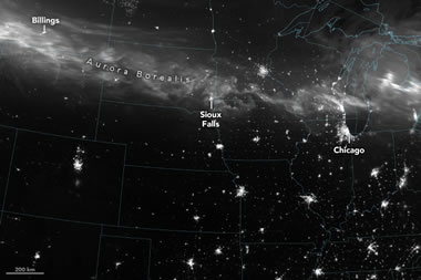
The VIIRS (Visible Infrared Imaging Radiometer Suite) on the Suomi NPP satellite can detect nighttime light in a range of wavelengths. In the image above from May 11, it could "see" the aurora borealis as a wispy white band across the northern United States. Image by Wanmei Liang, using VIIRS day-night band data from the Suomi National Polar-orbiting Partnership.
NASA Earth Observatory
The VIIRS (Visible Infrared Imaging Radiometer Suite) on the Suomi NPP satellite can detect nighttime light in a range of wavelengths. In the image above from May 11, it could "see" the aurora borealis as a wispy white band across the northern United States. Image by Wanmei Liang, using VIIRS day-night band data from the Suomi National Polar-orbiting Partnership.
The Seven Most Amazing Discoveries We've Made by Exploring Jupiter
Smithsonian

A composite image of Jupiter produced using data from the Juno spacecraft. Image by NASA/ JPL-Caltech / SwRI / MSSS / Kevin Gill.
Smithsonian
A composite image of Jupiter produced using data from the Juno spacecraft. Image by NASA/ JPL-Caltech / SwRI / MSSS / Kevin Gill.
White and Black Volcanoes of Saudi Arabia
NASA Earth Observatory

Contrasting colors of lava and ash reveal the geologic origins of Harrat Khaybar's volcanic cones.
NASA Earth Observatory
Contrasting colors of lava and ash reveal the geologic origins of Harrat Khaybar's volcanic cones.
What Are Cinder Cones?
Geology.com

Cumbre Vieja Volcano erupting cinders on the Canary Island of La Palma, in September, 2021.
Geology.com
Cumbre Vieja Volcano erupting cinders on the Canary Island of La Palma, in September, 2021.
Guyana Becomes Key Contributor to Global Crude Oil Supply Growth
U.S. Energy Information Administration
U.S. Energy Information Administration
Where is Guyana?
Geology.com
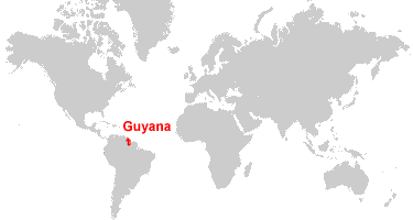
Guyana is located in northern South America. Guyana is bordered by the Atlantic Ocean to the north, Venezuela to the west, Brazil to the south, and Suriname to the east.
Geology.com
Guyana is located in northern South America. Guyana is bordered by the Atlantic Ocean to the north, Venezuela to the west, Brazil to the south, and Suriname to the east.
Louisiana's Disappearing Coastline
NASA Earth Observatory

This satellite image pair shows the surprising amount of land that has vanished from the Louisiana coast in a 6-year period. Although hurricanes are the main culprit for this destruction, other contributing factors include rising sea levels, subsidence of the land, oil and gas exploration, and degradation from oil spills. Images by Michala Garrison, using Landsat data from the U.S. Geological Survey.
NASA Earth Observatory
This satellite image pair shows the surprising amount of land that has vanished from the Louisiana coast in a 6-year period. Although hurricanes are the main culprit for this destruction, other contributing factors include rising sea levels, subsidence of the land, oil and gas exploration, and degradation from oil spills. Images by Michala Garrison, using Landsat data from the U.S. Geological Survey.
Mapping the Lava Caves of Auckland, New Zealand
BBC
Beneath the city of Auckland, New Zealand, there is a huge network of empty lava tubes. A new project aims to map this network of caves for preservation and safety purposes.
BBC
Beneath the city of Auckland, New Zealand, there is a huge network of empty lava tubes. A new project aims to map this network of caves for preservation and safety purposes.
Where is New Zealand?
Geology.com
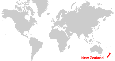
New Zealand is an archipelago of hundreds of islands, located southeast of Australia. New Zealand is bordered by the South Pacific Ocean and the Tasman Sea.
Geology.com
New Zealand is an archipelago of hundreds of islands, located southeast of Australia. New Zealand is bordered by the South Pacific Ocean and the Tasman Sea.
Weekly Rig Counts
Energy Information Administration
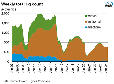
A total of 603 rigs were actively drilling for oil and natural gas during the week ending on Tuesday, May 7th, 2024. That is 128 rigs fewer than were active during the same week in 2023. The main reason for this reduction in rig count is increased drilling efficiency. Data for the weekly rig count is compiled by Baker Hughes Company.
Energy Information Administration
A total of 603 rigs were actively drilling for oil and natural gas during the week ending on Tuesday, May 7th, 2024. That is 128 rigs fewer than were active during the same week in 2023. The main reason for this reduction in rig count is increased drilling efficiency. Data for the weekly rig count is compiled by Baker Hughes Company.
Lightbox Jewelry Lowering Prices, Adding GIA "Verification"
JCKonline
When Lightbox Jewelry started selling lab-grown diamond jewelry in 2018, the price was $800 for an item with a one-carat diamond. Now they are selling one-carat items at $500, $600, or $900 depending upon color grade.
JCKonline
When Lightbox Jewelry started selling lab-grown diamond jewelry in 2018, the price was $800 for an item with a one-carat diamond. Now they are selling one-carat items at $500, $600, or $900 depending upon color grade.
Anglo American Confirms De Beers Is Up for Sale
JCKonline
Anglo American owns 85% of the company. The government of Botswana owns 15%. The company mines natural diamonds, produces the Lightbox brand of lab-grown diamonds, and is the iconic brand of the diamond industry.
JCKonline
Anglo American owns 85% of the company. The government of Botswana owns 15%. The company mines natural diamonds, produces the Lightbox brand of lab-grown diamonds, and is the iconic brand of the diamond industry.
Does This Gold - Advertised as "Recycled" - Have Positive Social and Environmental Benefits?
JCKonline
Does gold currently labeled as "recycled" really deliver the advertised benefits?
JCKonline
Does gold currently labeled as "recycled" really deliver the advertised benefits?
U.S. Bans Russian Uranium Imports, Key to Nuclear Fuel Supply
Gift Article from the Washington Post
From the article: "American companies pay roughly $1 billion a year for enriched uranium, the main fuel used by nuclear reactors, from Moscow."
Gift Article from the Washington Post
From the article: "American companies pay roughly $1 billion a year for enriched uranium, the main fuel used by nuclear reactors, from Moscow."
Images of the Northern Lights, Spotted in Unusual Places
Smithsonian

Normally, the aurora borealis is a spectacle reserved for viewers in northern latitudes. However, due to unusually strong solar activity recently, the phenomenon was visible to those living farther south, like people in New York, Indiana, Oregon, and California. The photo above shows a rare green and purple aurora. Image by National Park Service Photo / Kent Miller.
Smithsonian
Normally, the aurora borealis is a spectacle reserved for viewers in northern latitudes. However, due to unusually strong solar activity recently, the phenomenon was visible to those living farther south, like people in New York, Indiana, Oregon, and California. The photo above shows a rare green and purple aurora. Image by National Park Service Photo / Kent Miller.
Aurora Australis from Space
Geology.com
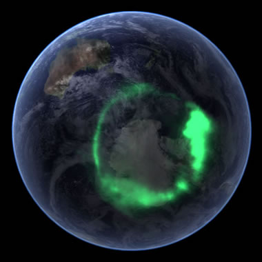
Aurora Australis: A composite satellite image of the Aurora Australis (southern lights) over Antarctica from space. The image was compiled by superimposing data of the Aurora Australis collected by NASA's IMAGE satellite atop of an image of Earth from a south polar perspective from the Blue Marble project. The result simulates what the Aurora Australis would look like from a satellite orbiting above. Image by NASA.
Geology.com
Aurora Australis: A composite satellite image of the Aurora Australis (southern lights) over Antarctica from space. The image was compiled by superimposing data of the Aurora Australis collected by NASA's IMAGE satellite atop of an image of Earth from a south polar perspective from the Blue Marble project. The result simulates what the Aurora Australis would look like from a satellite orbiting above. Image by NASA.
Retired Geologist Finds Bronze Age Arrowhead in His Backyard
Fox News
Andrew Beckly of Wellington, England is a retired geologist and an avid fan of Time Team (a British TV show about archaeology and history). He had recently rewatched the series when, by chance, he happened to unearth an archaeological treasure in his very own backyard.
Fox News
Andrew Beckly of Wellington, England is a retired geologist and an avid fan of Time Team (a British TV show about archaeology and history). He had recently rewatched the series when, by chance, he happened to unearth an archaeological treasure in his very own backyard.
Peat Landslide in Scotland's Shetland Islands
The Landslide Blog
The video above shows a peat landslide in action on May 7, 2024 in northern Scotland. Fortunately, nobody was hurt in the incident. Click here to read an accompanying article by Dave Petley of The Landslide Blog.
The Landslide Blog
The video above shows a peat landslide in action on May 7, 2024 in northern Scotland. Fortunately, nobody was hurt in the incident. Click here to read an accompanying article by Dave Petley of The Landslide Blog.
How a Fantastical Labyrinth Became a Crucial Habitat for Europe's Bats
Smithsonian

The Piusa Sand Caves in southern Estonia were tunnelled out by glass sand miners back in the 1920s. When the miners left, bats took up residence in the miles of underground tunnels. Now the caves are an important habitat for the local bat population. Image by Tpani, displayed here under a Creative Commons License.
Smithsonian
The Piusa Sand Caves in southern Estonia were tunnelled out by glass sand miners back in the 1920s. When the miners left, bats took up residence in the miles of underground tunnels. Now the caves are an important habitat for the local bat population. Image by Tpani, displayed here under a Creative Commons License.
Sand Grains from Around the World
Geology.com
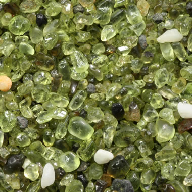
Green olivine sand from Papakolea Beach, Hawaii. The white grains are coral fragments, and the gray-black grains are pieces of basalt. If you think the grains have a "gemmy" appearance, olivine is the mineral name of a gemstone known as "peridot." This image represents a 10 millimeter x 10 millimeter view. Photograph by Siim Sepp, used here under a Creative Commons License.
Geology.com
Green olivine sand from Papakolea Beach, Hawaii. The white grains are coral fragments, and the gray-black grains are pieces of basalt. If you think the grains have a "gemmy" appearance, olivine is the mineral name of a gemstone known as "peridot." This image represents a 10 millimeter x 10 millimeter view. Photograph by Siim Sepp, used here under a Creative Commons License.
Complex Beauty in the Gulf of Oman
NASA Earth Observatory

NASA's new PACE (Plankton, Aerosol, Cloud, ocean Ecosystem) satellite captured this image of a phytoplankton bloom in the Gulf of Oman. NASA image by Joseph Knuble, using PACE data from NASA/GSFC.
NASA Earth Observatory
NASA's new PACE (Plankton, Aerosol, Cloud, ocean Ecosystem) satellite captured this image of a phytoplankton bloom in the Gulf of Oman. NASA image by Joseph Knuble, using PACE data from NASA/GSFC.
Satellite Views of Phytoplankton Blooms in Oceans and Seas
Geology.com

Phytoplankton Bloom Off New Jersey: An unusual phytoplankton bloom occurred in the Atlantic Ocean off the coast of New Jersey on July 6, 2016. This bloom received nutrients from a process known as "upwelling". Strong, persistent winds, blowing off the continent and towards the east, carried surface waters away from the coast. This brought cold, nutrient-rich waters up the continental slope to replace the waters that were blown out to sea. The result was a near-shore phytoplankton bloom. Similar blooms occur periodically along the Atlantic coast in the summer. This NASA satellite image was prepared by Jeff Schmaltz.
Geology.com
Phytoplankton Bloom Off New Jersey: An unusual phytoplankton bloom occurred in the Atlantic Ocean off the coast of New Jersey on July 6, 2016. This bloom received nutrients from a process known as "upwelling". Strong, persistent winds, blowing off the continent and towards the east, carried surface waters away from the coast. This brought cold, nutrient-rich waters up the continental slope to replace the waters that were blown out to sea. The result was a near-shore phytoplankton bloom. Similar blooms occur periodically along the Atlantic coast in the summer. This NASA satellite image was prepared by Jeff Schmaltz.
More Than Half of U.S. Landfills May Be Methane "Super-Emitters"
Smithsonian
From the article: "Aerial observations of hundreds of large landfills across 18 states found they are leaking 40 percent more methane than is reported to the EPA."
Smithsonian
From the article: "Aerial observations of hundreds of large landfills across 18 states found they are leaking 40 percent more methane than is reported to the EPA."
Chicago Museum Unveils the "Most Important Fossil Ever Discovered": the Feathered Dinosaur Archaeopteryx
Smithsonian
From the article: "Archaeopteryx provided the missing link between dinosaurs and the avians of today, serving as critical evidence for Charles Darwin's theory of evolution."
Smithsonian
From the article: "Archaeopteryx provided the missing link between dinosaurs and the avians of today, serving as critical evidence for Charles Darwin's theory of evolution."
EIA Expects U.S. Electricity Growth to be Mostly Met by Renewables
U.S. Energy Information Administration
In 2024, the EIA predicts that U.S. electricity generation will increase about 3%, with solar energy supplying about 60% of that growth. Generation from solar energy is on track to surpass generation from hydropower as early as 2025.
U.S. Energy Information Administration
In 2024, the EIA predicts that U.S. electricity generation will increase about 3%, with solar energy supplying about 60% of that growth. Generation from solar energy is on track to surpass generation from hydropower as early as 2025.
New Findings Point to an Earth-Like Environment on Ancient Mars
Los Alamos National Laboratory
From the article: "Manganese-rich sandstones indicate there were once habitable conditions in the Gale Crater."
Los Alamos National Laboratory
From the article: "Manganese-rich sandstones indicate there were once habitable conditions in the Gale Crater."
Rocks on Mars that Look Just Like Rocks on Earth
Geology.com

Photo of an outcrop of sedimentary rocks inside the Gale Crater on Mars. The rocks here are almost identical to some of the shales and siltstones found here on Earth. Image by NASA's Mars Curiosity Rover.
Geology.com
Photo of an outcrop of sedimentary rocks inside the Gale Crater on Mars. The rocks here are almost identical to some of the shales and siltstones found here on Earth. Image by NASA's Mars Curiosity Rover.
A Million Years Without a Megaslide
EOS Science News
From the article: "A new study goes deep into the Gulf of Alaska to examine the sixth-largest underwater landslide and investigate why a similar event hasn't happened since."
EOS Science News
From the article: "A new study goes deep into the Gulf of Alaska to examine the sixth-largest underwater landslide and investigate why a similar event hasn't happened since."
The Largest-Known Subaerial and Submarine Landslides
Geology.com
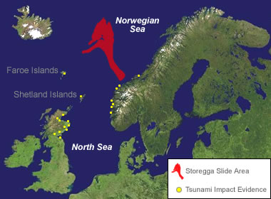
This article features Heart Mountain - largest-known subaerial landslide and Storegga - the largest-known submarine landslide.
Geology.com
This article features Heart Mountain - largest-known subaerial landslide and Storegga - the largest-known submarine landslide.
What Is Fool's Gold?
Geology.com
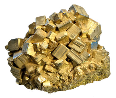
"Fool's gold" is a common nickname for pyrite. Pyrite received that nickname because it is worth virtually nothing, but has an appearance that "fools" people into believing that it is gold. With a little practice, there are many easy tests that anyone can use to quickly tell the difference between pyrite and gold.
Geology.com
"Fool's gold" is a common nickname for pyrite. Pyrite received that nickname because it is worth virtually nothing, but has an appearance that "fools" people into believing that it is gold. With a little practice, there are many easy tests that anyone can use to quickly tell the difference between pyrite and gold.
Tatooine, Trisolaris, Thessia: Sci-Fi Exoplanets Reflect Real-Life Discoveries
EOS

In 1977, the fictional world of Tatooine was immortalized on the silver screen in Star Wars: A New Hope (Episode IV). However, it wasn't until 2005 that astronomers discovered HD 202206 c, the first known exoplanet in a binary star system. What influence does real-life science have on science fiction... and vice versa? Image credit: Journal of Science Communication - JCOM.
EOS
In 1977, the fictional world of Tatooine was immortalized on the silver screen in Star Wars: A New Hope (Episode IV). However, it wasn't until 2005 that astronomers discovered HD 202206 c, the first known exoplanet in a binary star system. What influence does real-life science have on science fiction... and vice versa? Image credit: Journal of Science Communication - JCOM.
'Star Wars': Summary of the Franchise and Its Effect on Space Technology
Space.com

Pictured above: Mimas, one of Saturn's moons, bears an uncanny resemblance to the "Death Star" from Star Wars. Image by NASA/JPL/SSI.
Space.com
Pictured above: Mimas, one of Saturn's moons, bears an uncanny resemblance to the "Death Star" from Star Wars. Image by NASA/JPL/SSI.
USDA Plant Hardiness Zone Map
USDA.gov
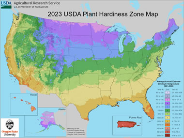
Are you thinking about starting a garden, but you're not sure which plants to choose? The U.S. Department of Agriculture has an interactive map that will help you make informed decisions based on your location in the United States. The different color zones represent the average annual extreme minimum temperature over a 30-year period. Simply type in your zip code to find your zone, and then you can use your zone number to choose plants with an appropriate hardiness range.
USDA.gov
Are you thinking about starting a garden, but you're not sure which plants to choose? The U.S. Department of Agriculture has an interactive map that will help you make informed decisions based on your location in the United States. The different color zones represent the average annual extreme minimum temperature over a 30-year period. Simply type in your zip code to find your zone, and then you can use your zone number to choose plants with an appropriate hardiness range.
Global Accounting of Earth's Rivers
NASA Earth Observatory

Quote from the article: "A novel approach to estimating river water storage and discharge also identifies regions marked by 'fingerprints' of intense water use" (shown in gray on the map above). NASA Earth Observatory images by Lauren Dauphin, using data from Collins, E.L., et al. (2024).
NASA Earth Observatory
Quote from the article: "A novel approach to estimating river water storage and discharge also identifies regions marked by 'fingerprints' of intense water use" (shown in gray on the map above). NASA Earth Observatory images by Lauren Dauphin, using data from Collins, E.L., et al. (2024).
Russia Energy Report
Energy Information Administration

This annual report reviews Russia's production and consumption of oil, natural gas, coal and renewable energy.
Energy Information Administration
This annual report reviews Russia's production and consumption of oil, natural gas, coal and renewable energy.
The Many Uses of Gold
Geology.com

The United States government currently mints coins from gold and other precious metals; however, they are intended for investment and collecting. They are not intended for use as legal tender.
Geology.com
The United States government currently mints coins from gold and other precious metals; however, they are intended for investment and collecting. They are not intended for use as legal tender.
The Highest Observatory on Earth Sits Atop Chile's Andes Mountains -- And It's Finally Open
Space.com
The Japanese University of Tokyo Atacama Observatory is at an altitude of 5640 meters above sea level. The higher the observatory, the less atmospheric distortion in its view.
Space.com
The Japanese University of Tokyo Atacama Observatory is at an altitude of 5640 meters above sea level. The higher the observatory, the less atmospheric distortion in its view.
Birthstone for the Month of May: Emerald
Geology.com
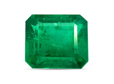
Emerald is a very popular green gemstone of the beryl mineral family. Image copyright iStockphoto / mikheewnik.
Geology.com
Emerald is a very popular green gemstone of the beryl mineral family. Image copyright iStockphoto / mikheewnik.
25 Years, 25 Images
NASA Earth Observatory

Happy 25th Birthday to NASA Earth Observatory! To celebrate, the people at NASA have created a short video featuring 25 of their favorite images. Above is a visualization of tiny atmospheric particles, or aerosols, as measured by satellites in the sky and sensors on the ground. Image by Joshua Stevens, using GEOS data from the Global Modeling and Assimilation Office at NASA GSFC.
NASA Earth Observatory
Happy 25th Birthday to NASA Earth Observatory! To celebrate, the people at NASA have created a short video featuring 25 of their favorite images. Above is a visualization of tiny atmospheric particles, or aerosols, as measured by satellites in the sky and sensors on the ground. Image by Joshua Stevens, using GEOS data from the Global Modeling and Assimilation Office at NASA GSFC.
Ten Amazing Facts About Tornadoes, Explained
Smithsonian

The photo above shows twin tornadoes near Pilger, Nebraska in 2014. Public domain image by Ethan Schisler / NOAA Photo Library.
Smithsonian
The photo above shows twin tornadoes near Pilger, Nebraska in 2014. Public domain image by Ethan Schisler / NOAA Photo Library.